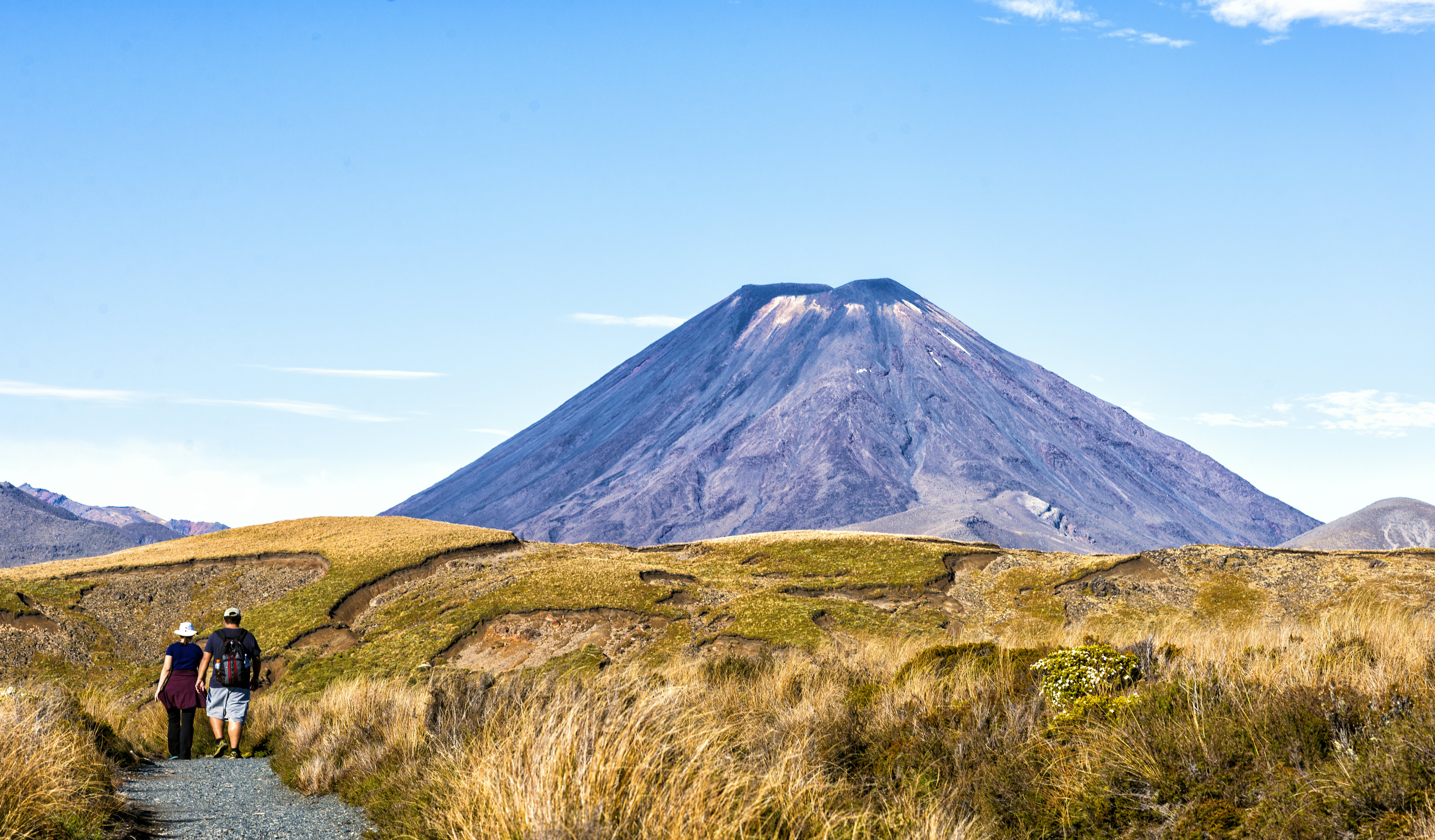
The Tongariro Alpine Crossing – in the heart of New Zealand’s North Island – is unlike any other hike in the country. Remnants of lava flows intertwine with an active crater; steam vents hiss gently; and emerald-hued lakes shimmer in the light beneath the towering volcanic peaks. It’s a place so iconic that even film director Peter Jackson couldn’t resist immortalizing it in his depiction of Mordor, with one of the volcanic peaks, Mt Ngāuruhoe, serving as Mt Doom in the Lord of the Rings trilogy.
Situated within the vast 786 sq km (303 sq mile) Tongariro National Park, the 20.2km/12.5-mile track is often celebrated as one of the most popular day hikes in the world. With such grand claims come crowds and visitors are struck by wonder as they traverse the alpine landscape. Yet, the Tongariro Alpine Crossing can also present danger for the unprepared, with highly changeable and sometimes extreme weather, challenging terrain, and a significant distance.
If hiking the Tongariro Alpine Crossing is on your New Zealand (Aotearoa) must-do list, here’s what you need to know.
Advertisement
Is the Tongariro Alpine Crossing worth doing?
In a word, yes – so much so that I’ve done it five times. Featuring three active volcanic mountains (Mt Tongariro, Ngāuruhoe, and Ruapehu), it’s located in a national park that’s been recognized by UNESCO for both its geographic features and its Māori cultural and spiritual significance.
The walk begins with the Devil’s Staircase: a zigzagging path of jagged volcanic debris winding upward to the Mangatepopo saddle. Suspended between the volcanic giants Mt Tongariro and Mt Ngāuruhoe, this is where the track opens up into a vast, dramatic amphitheater, which is encircled by towering, rugged cliffs.
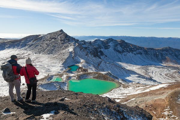
The track then winds through the South Crater’s desert-like expanse, climbing higher to a striking rock cairn. The summit of the Red Crater marks the highest point of the Tongariro Alpine Crossing: 1886m (6188ft) above sea level. Even after hiking the Crossing multiple times, I never grow tired of enjoying the panoramic view from this spot, with its views of Mt Taranaki, towering 138km (86 miles) to the west and the imposing figure of the perfectly conical summit of Mt Ngāuruhoe. This is also where you’ll look down on the Emerald Lakes (known as Ngā Rotopounamu or greenstone-hued lakes) and Blue Lake (Te Wai Whakaata o Te Rangihīroa or Rangihīroa’s mirror), their vibrant hues standing out in the stark, volcanic landscape.
The track also winds through a lush, dense forest, showcasing a stunning alpine vegetative landscape that contrasts sharply with the dramatic volcanic views you experience along the trail.

How difficult is the Tongariro Alpine Crossing?
Before 2007, this tramp (hike) was just called the “Tongariro Crossing.” The “Alpine” was added to its name to serve as a reminder that hikers are entering an alpine zone that demands respect, preparation, awareness of risks, and moderate fitness levels.
Key challenges include ascending 765m (2510ft) in altitude, the steep climb to the Red Crater and the slippery downhill sections with exposed ridgelines from the Red Crater to the Emerald Lakes. Consider all of this with the fact that you’re carrying about 5kg (11lbs) of gear and need to walk 20.2km (12.5 miles) in a 6–8 hour timeframe. These factors combined make the Tongariro Alpine Crossing a challenging yet achievable hike.
Being prepared is key. Go on practice hikes with a loaded backpack to build stamina and adapt to the terrain you’ll face on the hike.
Can you hike Tongariro Alpine Crossing with children?
The Tongariro Alpine Crossing is not recommended for children under 10. If you’re considering a Crossing with children, assess their fitness for a long, challenging hike with elevation. Explore shorter, easier tracks within Tongariro National Park suitable for young ones. You can also consider booking a local guide, who can assess the situation and provide the necessary support.

Do I need to make a booking to do the Tongariro Alpine Crossing?
As of October 2023, visitors to the Tongariro Alpine Crossing should book in advance via the Department of Conservation (DOC) booking system. Bookings are free and unlimited for the 2025 season. While a cap on visitor numbers isn’t currently in place, one may be implemented as early as October 2025.
Advertisement
Where is the Tongariro Alpine Crossing trailhead?
The Tongariro Crossing isn’t a loop track; you’ll start at one point and finish at another. The trailhead is the Mangatepopo parking lot, but you can also start from Waimarino (formerly National Park village), which would eliminate one shuttle from the equation. Accommodation options are very limited at Waimarino.
For better lodging choices close to the start of the track, most hikers opt to stay elsewhere: Tūrangi (34km/21 miles), Raetihi (48km/30 miles) or Ohakune (48km/29 miles) are all about a 45-minute drive away; from Taumarunui (62km/39 miles) it’s a one-hour drive, and from Lake Taupō (87km/54 miles) it takes 90 minutes. Tours and shuttles to the start of the track depart from all of these locations.
Ketetahi parking lot, on the other end of the track, is 26km (16 miles) from Tūrangi, 31km (19 miles) from Whakapapa Village, and 34km (21 miles) from Waimarino.

Why do I need to book a shuttle for the Tongariro Alpine Crossing?
Instead of jumping in your car to drive to the trailhead, you’ll need to book transportation for both your start and end points if you plan to walk the entire track. (Parking at the lots at both Mangatepopo and Ketetahi is limited, with a four-hour parking restriction during summer months.) Various local shuttle operators run from 6am to 5:30pm and can pick you up from the nearby towns.
Shuttle services also offer all-day parking in their designated lot (usually from 6am to 7pm at the Kaeteahi). I usually park at the Kaeteahi end, in the operators’ lot, and then take a 20-minute shuttle to the Mangatepopo trailhead. That way, I can enjoy walking all day and finish at my own pace without the stress of adhering to a set return shuttle schedule.
Shuttles also connect with public transport, the Intercity bus service and Kiwirail’s Scenic Northern Explorer train service, which operates between Auckland and Wellington and the nearby towns. The nearest airport to the park is Taupō, a 1½-hour drive from Whakapapa Village.
Which direction is best for the Tongariro Alpine Crossing?
The ideal direction is from the Whakapapa Village or Mangatepopo trailhead, ending at the Ketetahi parking lot. Mangatepopo (1120m/3674ft) is higher than Ketetahi (760m/2493ft), so heading this way reduces elevation gain. Hiking in the opposite direction is possible but not advisable. It adds 360m (1181ft) of ascent, involves walking against the flow, and involves ascending slippery scoria (a type of volcanic rock), making it challenging.
I find it much more fascinating to ascend through the shadows of Ngāuruhoe, than through the monotonous scenery from Ketetahi. The views make the climb more engaging and motivating.

What’s the best season to hike? Can you hike during winter?
The best time is from October to April, which coincides with summer in the southern hemisphere and is part of New Zealand’s tramping (hiking) season. While the weather can be pleasant, the track traverses an alpine environment with fluctuating weather patterns. Even during summer, you may often encounter frigid temperatures, strong winds, heavy rainfall, snow, freezing conditions, and reduced visibility. Snow can occur anytime.
It is possible to hike in the winter, but from May to October, there is an increased risk due to snow, ice, avalanche terrain, and sub-zero temperatures. Extra gear – such as crampons, ice axes and snow gaiters – is necessary, and it is strongly recommended that you take a guided trip with qualified operators such as Tongariro Guided Walks, Adrift Tongariro or Adventure Outdoors. Also, drive cautiously in winter; snow and ice may be present. Carry tire chains for mountain roads if needed.
When organizing your trip, include a few buffer days – even during the summer – as unpredictable weather can frequently cause cancellations of the Crossing.
What do I need to pack for the hike?
Ensure your daypack has a waterproof lining to store essentials: water, sunscreen, snacks, phone, toilet paper and camera. Wear suitable footwear (hiking boots or sturdy trail runners) and essential clothing like waterproof/windproof jackets, warm layers (thermals, down jackets, fleece), hats and gloves. I prefer merino for its warmth, breathability and quick-drying properties. I also carry a hip pack for my phone, compass, knife, sunscreen and snacks. Hiking poles can be helpful for steep ascents and descents.
If you’re hiking the track independently without a tour guide, carry a first aid kit, emergency shelter and a PLB (personal locator beacon). Due to limited and unreliable phone coverage, PLBs or InReach devices are recommended. You can hire PLBs from local DOC Visitor Centres or outdoor stores like Macpac and Kathmandu Bivouac.

Staying safe on the Tongariro Alpine Crossing
Stay on the track in volcanic areas to avoid steam vents and burns. The water along the track isn’t safe to drink, so bring enough water for the day. Eight toilet blocks are available 3–4km (1.9–2.5 miles) apart, with the longest stretch being between the South Crater and Red Crater toilets (about 4.5km/2.8 miles). Don’t forget to pack your own toilet paper and sanitizer. Finally, inform friends/family members about your plan and when you intend to complete it.
There are a number of resources that may also help you prepare for the hike: Visit the DOC Visitor Centre at Whakapapa Village for current weather, volcanic activity and track conditions, and learn about the region’s history and volcanic information. Also, check DOC’s Tongariro Facebook page for the latest updates on the park and crossing. You can view the Tongariro National Park weather forecast on NIWA’s website, the NZ Avalanche Advisory report, and the volcanic risk report. Alternatively, you can ask questions or get updates in the Tramping in New Zealand Facebook group from the walkers who have been to the park recently. Check the NZ Mountain Safety Council video on the Tongariro Alpine Crossing for more info.
Be a respectful tramper (hiker)
All waterways – including the Emerald and Blue Lakes – and the peaks of Tongariro, Ngāuruhoe and Ruapehu possess tapu (sacred) significance for the local iwi (Māori tribe). As a visitor, you’re encouraged to respect the sacredness by avoiding touching or entering any waterways and not climbing the summits.
Pets, bicycles and drones are strictly prohibited on the track.
My Tongariro Alpine Crossing got cancelled. What are some other walks to do in Tongariro National Park?
The Tama Lakes Track is a fantastic alternative to the Tongariro Alpine Crossing and an even better option for those seeking a world-class hiking track that remains slightly under the radar. It offers breathtaking views of Mt Ruapehu and Mt Ngāuruhoe and stunning alpine lakes. Accessible from Whakapapa Village, the round trip is 18km (11 miles), reaching a viewpoint at 1440m (4724 ft). On your return, you can take the 6km (3.7-mile) Taranaki Falls Walking Track, which features the photogenic 20m (66ft) high Taranaki Falls.
The Tama Lakes Track also offers a taste of New Zealand’s Great Walks, with parts forming the Tongariro Northern Circuit. Since the Crossing is part of this circuit, an overnight stay at nearby huts like Mangatepopo Hut or Oturere Hut is ideal. Book these huts in advance and bring extra gear, such as sleeping bags, food and crockery.
Whakapapa Nature Walk is an easy 15-minute loop near the Tongariro National Park Visitor Centre. Lake Rotopounamu track is another 6km (3.7-mile) walk, 30km (18 miles) from Waimarino. The 66km (41-mile) loop, Round the Mountain track in Tongariro, is an excellent option for seasoned hikers.